Comments and tips for those following the cycle/walking trail from Swardeston to Norwich
Sometime in the summer, stickers began appearing on lampposts, with a 19th C style silhouette. The Edith trail had arrived in Norwich.
I’ve had the leaflet, available free but now scarce, for some months. At the end of Edith’s fortnight of centenary commemorations, I did the trail. It felt a fitting end to an intense week.
Signage is often good – except towards the village itself, on that country lane where you most need assurance that you are on the right route. It’s brown for walkers, blue for cyclists but I found the cyclists’ route on the whole better for both – the outward leg, anyway, via Unthank Rd.
The leaflet doesn’t give directions, just a map to follow which is NOT TO SCALE. That is like having a clock not on time. It misleads about the length of the route.
I’ve oft read that Swardeston is 4 miles from Norwich and the signposts in the village say just that. As the crow flies perhaps, but not as the Elspeth walks or cycles. Although the fastest route is via the A140 Ipswich Road and the B1113, these include not nice bits for non drivers, such as a huge roundabout intersection on to a main road and then a fast traffic but lonely stretch on the B1113, though there is a path suitable for cycles or pedestrians along much of it – but like many paths, it stops and starts.
I am confident that the most direct route by cycle or foot is nearer 7 miles from Norwich rail station, which is included in the trail and is close to the Close.
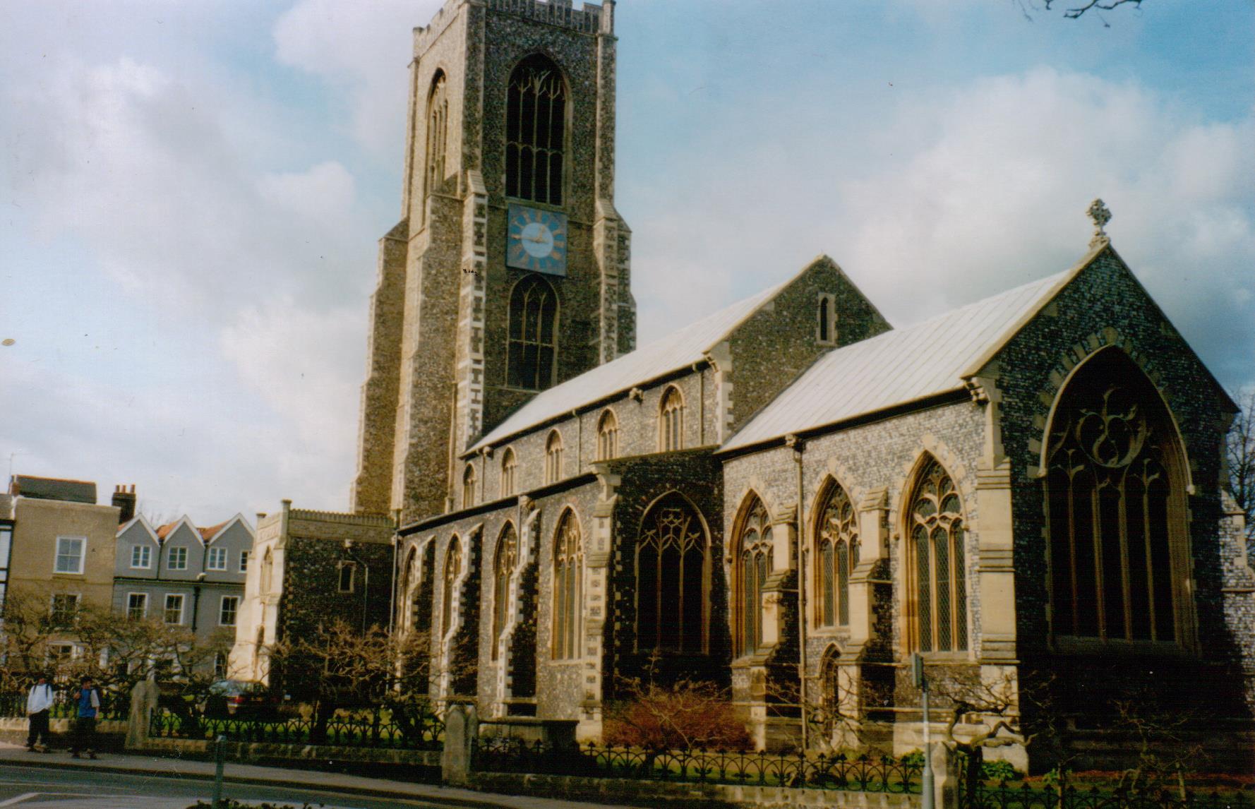
I am shocked that Edith walked this journey daily to school – not marked on the trail – at the Assembly House on Theatre Street, which you are directed right past. Today’s Norwich High School For Girls is on Newmarket Road which is a direct route from the city centre to Swardeston.
However – beware.
Many of the roads chosen are dull and have nothing to see or to do with Edith.
Ipswich Rd is a fast road with 1930s housing along it and a retail park with Tesco’s on it at the extreme, country end. I recall no other facilities – perhaps one pub? – and do not recommend the Marsh Harrier just beyond Tesco’s, which is not easy to access without a car anyway.
Hall Rd’s farthest end is basically industrial estate with no facilities.
Lakenham Way is an ex railway line running from behind Sainsbury’s on Queens Rd/ Brazen Gate to Hall Road. It’s fast and straight and flat, but as a shared path, can annoy all types of users. Mind the kink at the outskirts end.
Marston Lane is for cycles only – it’s too weeny for anything else and there’s little life down it except the private golf course. There’s nowhere to tie your bike if you want to walk on the marshes and I should warn walkers that for at least the second time on this trail, you are plunged into a wood. This is not a suitable lane for after dusk, nor is much of the route beyond Eaton – which you are now entering.
Newmarket Rd is full of fast traffic and many buses, but whom rarely stop here. Grand houses hide behind trees and open woods, so it’s eerie after dark, despite being so built up. There’s a shared cycle path and walkway, but there are few on it. After the Eagle Pub near the old N&N hospital, there are no facilities until you reach Eaton Village.
Unthank Rd – the city half – has shops and a little bit of buzz; there’s some nice pubs and cafes along or just off it. It rightly features on the trail, and feels safe by day or night, and there’s plenty of people about. Unthank Rd might be a better way to do this journey, especially if you’re coming back after dusk. The grand houses at its top (outskirts) end aren’t so tree lined as Newmarket Rd and it’s also quieter traffic wise – though the cars that are don’t drive slower and I saw some maniac driving into a well known mini mansion. It’s lit but again, not loads of people on foot.
As you cross the ring road, whatever arterial road you’ve chosen, beware – it has few pedestrian crossings and is too busy to do otherwise. If you’re on Newmarket Rd, stay on the left as you come out of the city, and use the crossing on Daniels Rd. If you’re on Unthank Rd, also stay left and go slightly down Mile Cross Road to get over the junction.
However, there’s an issue at the top of these roads and I am shocked that the Edith trail sends you over it, and without warning!
Unthank Rd at its outer end finishes at the top of Newmarket Rd, and so both roads make you face a terrifying crossing. If you are not on the left side of Newmarket Rd, you will need to cross a fast arterial road as it becomes a dual carriageway and major trunk road – and the cars prepare to go full legal speeds, or just start cutting back. There’s a tiny ‘watch out for people’ sign and a little half way point to stand. It’s crazy. Not on the map are a few roads between Newmarket and Unthank Rd such as Upton and Judges Walk. But there’s not a good solution to this.
Then go down the slip road into Eaton Village. (Note that if you try to avoid this crossing by going via Bluebell Road, there is also a lonely bit and a wooded bit and I wouldn’t recommend this after dusk either).
Once you arrive at Waitrose in Eaton Village centre, you are on the last of everything – shop (Waitrose, closes 8pm weekdays, 4pm a on a Sunday), cafes and pubs, toilets, and village shop a little further up on Intwood Road, Cringleford. Often the trail map doesn’t name streets and misses some off. This is your last chance to withdraw money, and soon the pavement will disappear as you reach the crossroad at Intwood Rd Eaton. Coming back there’s no sign to Norwich but it’s straight on if you’re following the cycle (brown route).
Keswick Hall can be accessed with one of the other turnings, but I don’t recommend it on foot as there’s high verges and as ever, fast drivers coming round bends in country roads.
I am shocked that you are led by the A47 – a thundering bypass – and onto what seems to be a private horse field – and not well signed. I couldn’t see how to get off and it and rejoin the trail. You meet the thunder of traffic (originally if not oddly likened to warfare) as you cross it on the Intwood road, next to some ominous pylons, and then dip into Intwood village, or the lack of it. After the Intwood Hall gate we’re-very-private-signs comes the church at which you go left. There’s a dribble of a stream and a barn about healing and a tiny mud track called Swardeston something. Don’t deviate, keep on this road which is long and lonely and has a wooded bit, and not great for jumping aside when traffic appears.
I never saw a sign to Swardeston or telling me you’re in it, but when at last houses start again, you are almost at Edith’s birthplace. The road kinks at a cattery and then on the other side is Cavell Barn and next door, Cavell House. The trail doesn’t say it but the signs on it do – this is private house!!! Keep walking – it still doesn’t look like much of a village yet – next to the large common whose growth is as high as a person, until you come to a proper T junction. You can go either way but the trails sends you right and then up towards a sports ground. Walkers are directed through what Lady Catherine De Burgh would call a pretty sort of wilderness – which didn’t look at that safe – so I followed the cycle path and the road. You’ll glimpse the vicarage which has a sign about a hair salon, though the church is on the other side of it.
I found that the trail wasn’t so accurate in the village, which never does have a cohesive centre. The church is found off Main Road, which is the B1113 from Norwich, and there is the bakery, garage (not a petrol sort), a farm shop open til 6 Mon-Sat but only til noon on Sunday, and the ex pub. So little food buying opportunities and no toilets or drink stop.
Note the memorial to Edith and others who died in the village in the first world war as you walk up the lane to the church. It’s not mentioned on the trail.
There’s a window with Edith on behind the altar and a display re wartime participants of the village. The Cavell Room is like a mini scout hut on the other side of the church which you can find by going through the door next to a picture of her. There is a DVD and a display on her.
On the main road, the B1113, towards Norwich, is the village sign not mentioned on the map but worth seeing as it’s about Edith.
The trail doesn’t tell you opening times for the church or the Cavell Room, without access to which your trip would feel wasted. I think it’s about a mile to walk round Swardeston.
I wouldn’t attempt this after dusk or evenings generally as I don’t think anything is open by night. Norwich is considered a safe city but some places on this route, the country bits especially, can feel eerier and dark. Today 18th Oct, dusk began ant 6 and it was dark by 730pm, but next weekend, the clocks change and it’ll be an hour earlier. Note if you’re visiting from elsewhere in Britain, daylight varies and the north enjoys more in summer but less in winter.
Despite calling it a green pilgrimage, I would actually say it is better by bus or car.
Warning re buses: they are expensive and a single is often nearly as much as a return.
Rural buses can have big gaps in the timetable and stop early (c4pm) and not run on Sundays or Bank Holidays. The recommended bus is a First bus 37, the purple line, but there are buses to Cringleford (by Konnect) and Eaton (Anglia) but not the same bus company and tickets are not valid between companies. Buses do not run on the outer part of Unthank Rd but the inner part has regular buses which run to the railway station via the city centre.
—————————————————-
I used the walk to think more of Edith; perhaps I’ll write about her myself, as I still feel the woman, her feelings and relationships are not unlocked by anything I’ve seen or read so far.